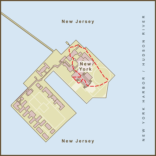
For so many immigrants, stepping off a ship onto Ellis Island was synonymous with arrival in New York City. Many years later, after the immigration station had closed and the buildings lie decaying, the US Supreme Court would decide that Ellis Island, with one small exception, was part of New Jersey.
The original colonial land grant for New Jersey defined it's border as the waterline of New York Bay and the Hudson River, meaning that the water and all islands within it belonged to New York. Most treaties place borders in the middle of natural borders like lakes and rivers. New Jersey tried to fight the claim starting in the early 1800s. In 1834 a compact between New York and New Jersey and ratified by the US Congress set the border as the middle of the Hudson River. This put jurisdiction and bragging rights over the island completely in New Jersey which they were quick to assert and claim in a court filing. The case went all the way up to the Supreme Court. New York fought hard but in the end was awarded only the small 3.3 acre section of the original island. Since that border follows the island's original shoreline it appears quite random today and passes through the middle of numerous buildings. The majority of the current island (most of it created by landfill from the digging of New York City subway tunnels) is now officially part of the State of New Jersey. Payback for Jersey's actions and perhaps the best argument for custody came from then Mayor Rudy Giuliani who remarked that his Italian father "never intended to emigrate to New Jersey."
In the pre-colonial days, Ellis Island was one of several, oyster-rich islands on the western tidal flats of Upper New York Bay. Other nearby islands included Liberty Island (originally Bedloe's Island and site of the Statue of Liberty) and Black Tom Island (named after an African-American that lived on the island according to local legend). Before becoming known as Ellis Island, it had been known as Dyre's Island, Bucking, Gibbet (Gibbet's being cages for displaying the dead bodies of convicted pirates), and lastly, Little Oyster Island. Samuel Ellis acquired the island during the American Revolution and first tried to sell it in 1785. New York State leased the island in 1794 until the Federal Government bought the island in 1808 and began expanding it before opening it as an immigration station in 1892.
Source: en.wikipedia.org/wiki/Ellis_island & Google Maps
Via Flickr:
For so many immigrants, stepping off a ship onto Ellis Island was synonymous with arrival in New York City. Many years later, after the immigration station had closed and the buildings lie decaying, the US Supreme Court would decide that Ellis Island, with one small exception, was part of New Jersey.
The original colonial land grant for New Jersey defined it's border as the waterline of New York Bay and the Hudson River, meaning that the water and all islands within it belonged to New York. Most treaties place borders in the middle of natural borders like lakes and rivers. New Jersey tried to fight the claim starting in the early 1800s. In 1834 a compact between New York and New Jersey and ratified by the US Congress set the border as the middle of the Hudson River. This put jurisdiction and bragging rights over the island completely in New Jersey which they were quick to assert and claim in a court filing. The case went all the way up to the Supreme Court. New York fought hard but in the end was awarded only the small 3.3 acre section of the original island. Since that border follows the island's original shoreline it appears quite random today and passes through the middle of numerous buildings. The majority of the current island (most of it created by landfill from the digging of New York City subway tunnels) is now officially part of the State of New Jersey. Payback for Jersey's actions and perhaps the best argument for custody came from then Mayor Rudy Giuliani who remarked that his Italian father "never intended to emigrate to New Jersey."
In the pre-colonial days, Ellis Island was one of several, oyster-rich islands on the western tidal flats of Upper New York Bay. Other nearby islands included Liberty Island (originally Bedloe's Island and site of the Statue of Liberty) and Black Tom Island (named after an African-American that lived on the island according to local legend). Before becoming known as Ellis Island, it had been known as Dyre's Island, Bucking, Gibbet (Gibbet's being cages for displaying the dead bodies of convicted pirates), and lastly, Little Oyster Island. Samuel Ellis acquired the island during the American Revolution and first tried to sell it in 1785. New York State leased the island in 1794 until the Federal Government bought the island in 1808 and began expanding it before opening it as an immigration station in 1892.
Source: en.wikipedia.org/wiki/Ellis_island
Thursday, July 07, 2011
A Map of the Strange Border Between New York & New Jersey on Ellis Island
Subscribe to:
Post Comments (Atom)
1 comment:
While the boundary is generally depicted correctly, it could be rendered with greater accuracy.
After the decision of the U.S. Supreme Court in 1998 ruling that additions to the island after 1833 were indeed a part of New Jersey, the court followed up with an accurate description of the boundary in New Jersey v New York, 526 U.S. 589 (1999). The survey information given is precise to 1/1000th of a foot.
Post a Comment