Monday, August 22, 2011

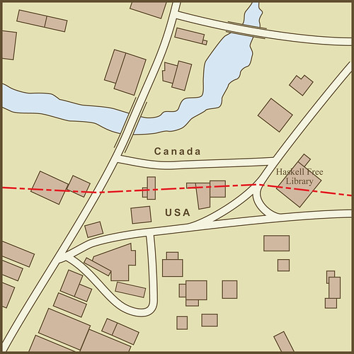
A Map of the Border Between the USA and Canada as it Passes Through the Town of Derby Line, Vermont

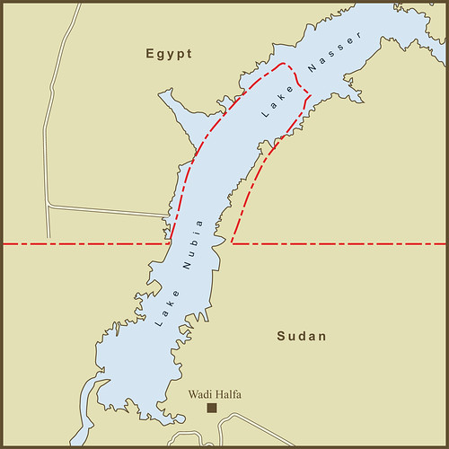
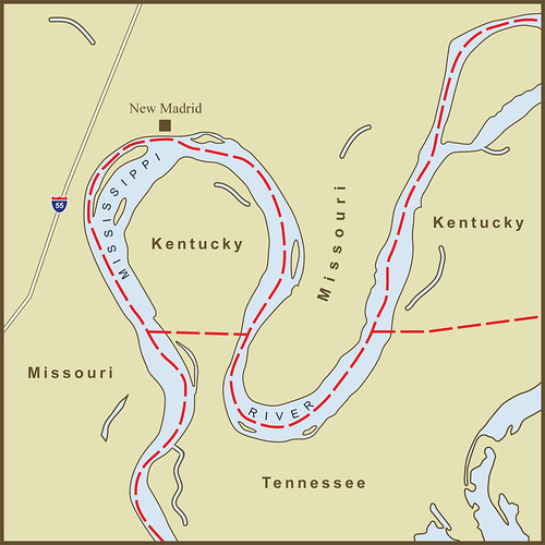
The story of Derby Line Vermont begins with a mistake and ends with an intentional act inspired by the mistake. For most of it's 2000 mile length, the USA / Canada border follows the 45th parallel. I have already written about the exception at the Northwest Angle in Minnesota that was created due to an error about how far North the Mississippi River went. Here in Vermont, the surveyors were intending to follow the 45th parallel, they were just a bit sloppy in their work and unintentionally marked the line too far North. The Town developed along the line along with it's sister town, Stanstead Quebec on the Canadian side.

Sometime in the latter part of the 1800s, Carlos Haskell an American met Martha Stewart (not that Martha Stewart) who had grown up on the Canadian side. They married and settled in Derby Line. Sometime around the turn of the century, they decided to honor the town's erratic border by building a library and opera house right on the border so that Americans and Canadians would both be able to use it. If I were erecting such a monument, I think I would have aligned the building so the border passed symbolically through the middle. Not so with the Haskell Free Library as it came to be known. The border passes diagonally through the building. The line is marked in the floor (you can see pictures of the interior at the CLUI link below). The line was requested by the insurance companies so they would pay only for damages to their part of the building.

In the library, the reading room is on the US side while the stacks are on the Canadian side. In the upstairs opera house, most of the seats are on the US side while the stage is on the Canadian side. This has prompted locals to call it alternatively, "the only library in the USA with no books" and "the only opera house in the USA with no stage".

Having such a small town straddles an international border invites a different perspective on international relations. The Center for Land Use Interpretation has an essay about the town on their website. The author makes the comment that two kids having a game of catch across the border would be perfectly legal. However, each time someone caught the ball they would have to walk over to the customs office to declare the ball.

When the Haskell's built the library, their intention was that people from both sides of the border would be able to use it. There are doors on the Canadian and USA side to enable this. The town also has several small roads that cross seamlessly across the border. All of this is threatened in the post-9/11 world because open, fuzzy borders make the US Department of Customs and Immigration nervous. There have been talks to tighten the links but, according to Wikipedia at least, the Haskell Free Library remains free and open to American and Canadian alike.

Sources:
http://en.wikipedia.org/wiki/Derby_Line,_Vermont
http://web.archive.org/web/20070618080148/http://www.cnn.com/2007/US/05/26/border.quirk.ap/index.html
http://www.clui.org/lotl/v29/m.html

Thursday, July 28, 2011

The Border Between Egypt & Sudan at the Wadi Halfa Salient

See the 52 villages in the map? No? That's because they were flooded by the damning of the Nile and the creation of Lake Nasser (known as Lake Nubia in Sudan). The strange bulge (known as a salient in cartography parlance) along this portion of the Egypt-Sudan border was originally surrounded the villages that dotted this section of the Nile.

Egypt and Sudan have 3 areas of land under dispute and a fourth that neither country claims. The original 1899 border between the two countries ran straight along the 22nd North Parallel line with no deviations. In 1902, Britain amended the border to account for some tribal and administrative issues. There were 52 villages where the Nile River crossed the 22nd Parallel. It was decided that these villages would be easier to maintain from the Sudanese side of the border so the border was changed to how it appears above. There appears to be a stretch of rough and desolate terrain North of this area that separates it from the next set of villages in current maps.

Egypt now claims this area along with the other two areas (Bir Tawil and the Hala'ib Triangle) in dispute. They maintain a military presence in the other two but not here as there is little of interest to guard. My map of Bir Tawil and the Hala'ib Triangle is here.

I've also made a map of the area showing the location of the former towns and ruins based on a 1953 British survey map.

Source: Wikipedia

Thursday, July 07, 2011

A Map of the Strange Border Between New York & New Jersey on Ellis Island

For so many immigrants, stepping off a ship onto Ellis Island was synonymous with arrival in New York City. Many years later, after the immigration station had closed and the buildings lie decaying, the US Supreme Court would decide that Ellis Island, with one small exception, was part of New Jersey.

The original colonial land grant for New Jersey defined it's border as the waterline of New York Bay and the Hudson River, meaning that the water and all islands within it belonged to New York. Most treaties place borders in the middle of natural borders like lakes and rivers. New Jersey tried to fight the claim starting in the early 1800s. In 1834 a compact between New York and New Jersey and ratified by the US Congress set the border as the middle of the Hudson River. This put jurisdiction and bragging rights over the island completely in New Jersey which they were quick to assert and claim in a court filing. The case went all the way up to the Supreme Court. New York fought hard but in the end was awarded only the small 3.3 acre section of the original island. Since that border follows the island's original shoreline it appears quite random today and passes through the middle of numerous buildings. The majority of the current island (most of it created by landfill from the digging of New York City subway tunnels) is now officially part of the State of New Jersey. Payback for Jersey's actions and perhaps the best argument for custody came from then Mayor Rudy Giuliani who remarked that his Italian father "never intended to emigrate to New Jersey."

In the pre-colonial days, Ellis Island was one of several, oyster-rich islands on the western tidal flats of Upper New York Bay. Other nearby islands included Liberty Island (originally Bedloe's Island and site of the Statue of Liberty) and Black Tom Island (named after an African-American that lived on the island according to local legend). Before becoming known as Ellis Island, it had been known as Dyre's Island, Bucking, Gibbet (Gibbet's being cages for displaying the dead bodies of convicted pirates), and lastly, Little Oyster Island. Samuel Ellis acquired the island during the American Revolution and first tried to sell it in 1785. New York State leased the island in 1794 until the Federal Government bought the island in 1808 and began expanding it before opening it as an immigration station in 1892.

Source: en.wikipedia.org/wiki/Ellis_island & Google Maps

Via Flickr:
For so many immigrants, stepping off a ship onto Ellis Island was synonymous with arrival in New York City. Many years later, after the immigration station had closed and the buildings lie decaying, the US Supreme Court would decide that Ellis Island, with one small exception, was part of New Jersey.

The original colonial land grant for New Jersey defined it's border as the waterline of New York Bay and the Hudson River, meaning that the water and all islands within it belonged to New York. Most treaties place borders in the middle of natural borders like lakes and rivers. New Jersey tried to fight the claim starting in the early 1800s. In 1834 a compact between New York and New Jersey and ratified by the US Congress set the border as the middle of the Hudson River. This put jurisdiction and bragging rights over the island completely in New Jersey which they were quick to assert and claim in a court filing. The case went all the way up to the Supreme Court. New York fought hard but in the end was awarded only the small 3.3 acre section of the original island. Since that border follows the island's original shoreline it appears quite random today and passes through the middle of numerous buildings. The majority of the current island (most of it created by landfill from the digging of New York City subway tunnels) is now officially part of the State of New Jersey. Payback for Jersey's actions and perhaps the best argument for custody came from then Mayor Rudy Giuliani who remarked that his Italian father "never intended to emigrate to New Jersey."

In the pre-colonial days, Ellis Island was one of several, oyster-rich islands on the western tidal flats of Upper New York Bay. Other nearby islands included Liberty Island (originally Bedloe's Island and site of the Statue of Liberty) and Black Tom Island (named after an African-American that lived on the island according to local legend). Before becoming known as Ellis Island, it had been known as Dyre's Island, Bucking, Gibbet (Gibbet's being cages for displaying the dead bodies of convicted pirates), and lastly, Little Oyster Island. Samuel Ellis acquired the island during the American Revolution and first tried to sell it in 1785. New York State leased the island in 1794 until the Federal Government bought the island in 1808 and began expanding it before opening it as an immigration station in 1892.

Source: en.wikipedia.org/wiki/Ellis_island

Monday, June 27, 2011

A Map of the very strange border(s) between the Netherlands and Belgium at Baarle-Nassau

Without going into excruciating detail about allegiances to dukes, lords and kings, it is hard to explain the origin if this rather unique set of international borders. Suffice it to say that the land was bought, sold, and loaned through many generations to the point where the current land owners felt allegiance to either the Dutch or Belgian side of the border. When it came time to make the border official as art of the 1843 Treaty of Maastricht, 5732 separate parcels of land had to have their nationality laid down separately.

Fortunately the borders are all friendly. In fact, there were several opportunities to clean things up in subsequent treaties and negotiations that the residents refused to act on. The residents of Baarle-Nassau seem to enjoy their quirky borders and the ramifications they present.

There is at least one border line that passes directly through a building. With borders sometimes passing through the middle of properties, taxes were sometimes a challenge in the area. To clarify matters, the Dutch government set the rule that taxes would be paid to the country your front door opened up on. With taxes being higher on one side of the border than the other, the ruling was an invitation for creative renovations. If shop keepers didn't like the taxes they were paying, they were known to just move their front door so that it opened on the other country.

The primary border between the two countries lies about 5 kilometers south of Baarle-Nassau... just a short distance beyond the bottom of this map. What is truly unique about this set of borders is that it happens completely inside the Netherlands border. These are Belgian exclaves inside the Netherlands. But even more amazing is that there are Dutch exclaves completely inside the Belgian exclaves. The smallest plot, identified as H12 is just 28,331 square feet (a bit more than 1/2 an acre) in size. With all of the dysfunction between Israel and the Palestinians over land swaps, it is nice to see two countries getting along so well that there's no need to swap.

Sources:
Google Maps
http://ontology.buffalo.edu/smith/baarle.htm
http://en.wikipedia.org/wiki/Baarle-Nassau

Wednesday, June 22, 2011

A Map of the Former Town of Monticello, CA in Relation to Today's Lake Berryessa

Where Lake Berryessa now stands there once was a fertile valley full of farms, orchards and the small town of Monticello, California. Before Monticello there were the Adobe buildings that were part of the Mexican-owned Rancho de Los Putahs. And before the Spanish arrived, there was the Patwin village of Topaidihi. All of this is now lost below the waters of Lake Berryessa.

Berryessa comes from the Basque family name of the early Spanish settlers of the valley (Berelleza was the likely original spelling).

Berryessa Valley as it came to be known, was first settled by the Patwin and Pomo Indians who lived there for thousands of years. A 1948 archaeological survey of the valley found the remains of approximately 150 Native American villages. They lived easily off the abundant trees, plants, and animals of the valley and surrounding hills. According to ome history, bears roamed the hills and, over time, created trails that were later used by the Berreyesa family to get their cattle up and over the mountains and into the valley.

The first Spanish settler in the valley was Nicolas Antonio Berreyesa who was born in 1761 in Sinaloa Mexico of Spanish parents. He arrived in Northern California as part of the 1776 De Anza Colonization Expedition. In 1779, Nicolas married the daughter of Gabriel Peralta, one of Anza’s soldiers. They had nine children together including, Nasario Antonio who would eventually establish the first ranch in Berryessa Valley.

Two of Nasario's sons, Sisto and Antonia, were in the Mexican Army and based in San Francisco. In 1838 they married the Higuerra twins, Nicholasa and Maria Anatasia and moved up to their father's rancho in the valley a short time later. In 1843, the two sons became the official owners of what came to be known as Rancho de la Putas through a Mexican land grant.

There are several possible origins regarding use of the word Putas in the rancho name. One is that the local Patwin tribes engaged in "licentious behavior" and the river became known as the Rio de los Putos (putah being the word for prostitute in Spanish). Another version says that the name evolved from, "puta wuwwe" (grassy creek), the Miwok name for the creek. In that telling, any similarity to the Spanish "putah" was coincidental. I tend to believe the latter as while they may have used an unflattering name for the Indians and the creek, it seems less likely that they would intentionally name their ranch, Ranch of the Prostitutes.

By 1866, most of the original Berryessa family had died, been killed, or had sold the land to pay off family debts. Most of this seems associated with the transition of California from Mexican to U.S. territory. Knowing the valley's reputation as perhaps the most fertile in the country, developers bought up the land and cut it up into many small plots. A year later, the valley was full of productive farms.

The town of Monticello was established shortly thereafter. A hotel was then built as a stopover point for the stagecoach that ran between Napa and a large mining operation in Knoxville, north of the valley. Monticello was known for it's annual rodeo that had grew out of a tradition at one of the valley ranches.

Although the farms and orchards of the valley thrived, discussions of building a dam and flooding the valley occurred as early as 1906. It became official in 1954 under President Eisenhower and construction started the same year. The residents of the town and valley tried to fight the movement but were unsuccessful. Life Magazine sent Dorothea Lange to document their plight but never published the photos or story. The town was bought up and leveled. The town cemetery was dug up and moved to Spanish Flat in the hills just West of the lake. There is also a small museum in Spanish Flat that was created by surviving family members with a number if photos and artifacts from Monticello.

In one of the historical accounts I read, a local farmer was quoted as saying, "they took our land away like we were Indians." I'm not sure he was aware of the irony of his statement. Perhaps if the bears could talk, they would complain of their loss of habitat. The Indians have surely complained with rarely anyone willing to listen. History describes the Berryessa family as doing themselves in through gambling debts and the like but i doubt it was that simple. With the land changing from Mexican to American hands there were bound to be conflicts and new claims of dominion. Alas, not even the white man's land is safe in the evolving landscape now seemingly a picturesque, tranquil lake.

Sources for the Map & History
http://nrs.ucdavis.edu/quail/natural/Human_Berelleza.htm
http://www.bellavistaranch.net/suisun_history/berryessa1-delaplane.html

Tuesday, May 24, 2011

A Map of the Strange Kentucky Border at the New Madrid Bend in the Mississippi River

The border of Kentucky at what is known as "The New Madrid Bend" owes it's strangeness to the serpentine path of the Mississippi River. The River was supposed to define the western edge of the state of Kentucky and the Southern edge of Missouri. The result is an exclave peninsula of land in Kentucky that is completely surrounded by Missouri and Tennessee. To drive here from the rest of Kentucky, you must leave the state, drive through Tennessee and come back into Kentucky.

This spot along the Mississippi River is also the site of several historic events. Most notable is the "Battle of Island Ten" in the Civil War where Confederate Troops occupied Island Ten (now mostly part of the shoreline at the southern-most part of the bend in the map). The plan was to block and defeat the Union Troops coming down the Mississippi from the North at a slow point in the river. The plan didn't work so well. Although this was a potentially vulnerable spot in the river, Island Ten was also remote and could only be re-supplied by a single road through swamp and marsh land (the Union eventually succeeded in cutting off Confederate supply lines).

Mark Twain wrote about the area in his book, "Life on the Mississippi" and in particular about the feud between the Darnell and Watson families. One family was from Kentucky, the other from Tennessee. According to Twain, the two families attended the same church at what is/was known as Compromise Landing. The Church straddled the border between Kentucky and Tennessee enabling the families to walk up the aisle on their side of the church and attend services without stepping into the other state.

Lastly, New Madrid was the epicenter for several of the strongest Earthquakes ever felt in the United States in 1811 and 1812. According to Wikipedia, the earthquakes were so disruptive that they reportedly reversed the course of the Mississippi River around the area.

Read more...
New Madrid Bend: http://en.wikipedia.org/wiki/Kentucky_Bend
Battle of Island Number Ten: http://en.wikipedia.org/wiki/Battle_of_Island_Number_Ten
The Earthquakes: http://en.wikipedia.org/wiki/1812_New_Madrid_earthquake

Wednesday, April 20, 2011

A Map of "The Five Points" neighborhood in New York City and its relationship to today's streets and the old Collect Pond.

This is my first attempt to try to render the story of "The Five Points" Neighborhood in historical layers. The neighborhood or more aptly, slum was also known as Paradise Square was always notorious but was made famous more recently as the setting for Martin Scorcese's, "Gangs of New York" film.

Here’s the story...
The area that was eventually to become the Five Points was originally a spring-fed fresh water pond known as the Collect Pond. It shows up clearly on British maps of Manhattan around the time of the American Revolution. The pond was a major source of drinking water in the colonial era. There was also an area of the pond known as “Cow Bay” where farmers would bring their cows to drink.

As lower Manhattan grew, several breweries and tanneries set up shop near the Collect. This included Coulter’s Brewery which was built in 1792. Coulter’s building would eventually become known as “The Old Brewery,” perhaps the Five Point’s most infamous tenement. The breweries and tanneries no doubt benefitted greatly from their proximity to the Collect Pond’s fresh water but it was not a mutually beneficial relationship. Over time, the pond had become quite polluted and smelly and the city made plans to fill it in. The Canal that gave Canal Street it’s name was built, in part, to drain the Collect and it’s surrounding marsh. The City backfilled the collect with garbage and debris around 1811 and began allowing buildings to be erected. The pond however had been poorly filled and was still being fed by the underground spring. The area remained wet, muddy and mosquito infested. As a consequence of this, anyone that could move out of the area did. In the 1830s, more and more tenements were built on the soggy ground and began to settle and lean almost as soon as they were completed. Little Water Street, which had once been the footpath to Cow Bay was now a dangerous, crime-infested alley. There was a building at the northern end of Little Water Street known as “Jacob’s Ladder” because the front steps were badly rotten, broken and misaligned.

Eventually only the poorest of the poor chose to live in the area known initially as Paradise Square and later as Five Points. This included freed black slaves and a group of immigrants arriving from Europe. The Potato Famine had hit Ireland in the 1840s prompting a huge exodus. As they arrived in New York poor and destitute, many ended up in the Five Points. As many as a thousand may have lived in “The Old Brewery” which had been broken up into tiny, one-room “dwellings”. It was said that there was a murder every night in the brewery for months on end.

The emergence of The Five Points as a crime-ridden slum feels like destiny in action. Had the Potato Famine happened a decade later, the Irish might have ended up in a different neighborhood. If the Collect Pond had not become polluted then drained and backfilled, there would not have been the cheap, undesirable land to build on. Had the buildings not been built on soggy, marshland, they might have been more stable, desirable and able to charge more rent.

With all of the above conditions in place, in came the poor and the crime associated with so many scrambling to scratch out an existence. The area was famous for numerous gangs including the “Dead Rabbits” featured in Scorcese’s movie. The neighborhood had many alleys like “Bottle Alley” and “Bandit’s Roost” that were gang hangouts. Some gang members eventually ended up at “The Tombs” prison after being convicted of a crime. The Tombs was built in 1838 in the Egyptian Revival style in the hopes its ominous appearance would be a natural deterrence against crime. It too was built over the Collect Pond and suffered as a result. The foundation sank and leaked eventually forcing the building to be destroyed. The Tombs was replaced twice with newer buildings. The current nearby detention center is still referred to as The Tombs by some law enforcement officials.

Despite the seedy history of the Five Points, some good did come out of the area. There were a number of dance and music halls in the area. One came to be known as Almack’s Dance Hall. Both the Irish and African Americans living in the area frequented it creating a mix of African and Irish dance traditions. It is said that this combination led to what eventually became what we know now as tap dance.

Monday, April 18, 2011

A Map of the Strange Border Between Sweden and Finland on Märket Fyr

How did I not find this awesome border sooner. An island less than 1200 feet long with a border that takes more twists and turns than a Stieg Larsson novel. It is now possible to walk the length of this short island and cross an international border three times. However, despite the strangeness of the border, Sweden and Finland have always agreed on shared ownership of the skerry (a Norse word for rock in the sea) and the serpentine border results from an effort to correct Finland's accidental siting of the island's lighthouse on the Swedish side of the border. The island is otherwise a textbook example of international cooperation and agreement.

Market Island or Reef (Market Fyr in Swedish) is part of the larger Aland Island chain that lies between Sweden and Finland. According to Wikipedia, ownership of the islands has been shared ever since the Treaty of Fredrikshamn in 1809. Prior to the building of the lighthouse, the border between the two countries passed down the middle of the skerry so that half the island's land mass was in Sweden and half was in Finland. When it was discovered that Finland had accidentally built the lighthouse on Sweden's half of the island, a fix was necessary. The resulting zig-zag border allows the lighthouse to be in Finland while retaining the 50/50 split in land area and avoids any changes to the maritime border. Any alterations of that would have resulted in a change in fishing rights… Perhaps the one thing that might have caused strife between the two herring-loving nations.

Wednesday, March 23, 2011

Newt Gingrich on Libya

Newt Gingrich on March 7th:
"Exercise a no-fly zone this evening."

Newt Gingrich on March 7th:
"I would not have intervened. I think there were a lot of other ways to affect Gaddafi."