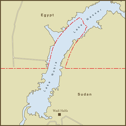
See the 52 villages in the map? No? That's because they were flooded by the damning of the Nile and the creation of Lake Nasser (known as Lake Nubia in Sudan). The strange bulge (known as a salient in cartography parlance) along this portion of the Egypt-Sudan border was originally surrounded the villages that dotted this section of the Nile.
Egypt and Sudan have 3 areas of land under dispute and a fourth that neither country claims. The original 1899 border between the two countries ran straight along the 22nd North Parallel line with no deviations. In 1902, Britain amended the border to account for some tribal and administrative issues. There were 52 villages where the Nile River crossed the 22nd Parallel. It was decided that these villages would be easier to maintain from the Sudanese side of the border so the border was changed to how it appears above. There appears to be a stretch of rough and desolate terrain North of this area that separates it from the next set of villages in current maps.
Egypt now claims this area along with the other two areas (Bir Tawil and the Hala'ib Triangle) in dispute. They maintain a military presence in the other two but not here as there is little of interest to guard. My map of Bir Tawil and the Hala'ib Triangle is here.
I've also made a map of the area showing the location of the former towns and ruins based on a 1953 British survey map.
Source: Wikipedia
Thursday, July 28, 2011
The Border Between Egypt & Sudan at the Wadi Halfa Salient
Subscribe to:
Post Comments (Atom)
No comments:
Post a Comment